Cutting-Edge Science|HKUST Collaborates with Chang Guang to Develop High-Resolution "Carbon Satellite"
On September 1, 2024, Professor Hui Su, a Global STEM Professor at the Department of Civil and Environmental Engineering at HKUST and the Co-Founder of Stellerus Technology Limited, was interviewed by Ta Kung Pao. The full interview report is as follows:
Coverage in Ta Kung Pao
HKUST partnered with Chang Guang Satellite Technology Company Ltd (Chang Guang) of Jilin Province to launch a satellite in 2023. HKUST later announced another collaboration with the Changchun Institute of Optics, Fine Mechanics and Physics (CIOMP) under the Chinese Academy of Sciences to develop a high-resolution "carbon satellite" with an innovative addition: methane monitoring. In an interview with Ta Kung Pao, Professor Hui Su, one of the project’s co-leads, stated, "Our goal was to complete the carbon satellite by the end of 2025." Co-lead Professor Limin Zhang, Chair Professor and Head of the Department at HKUST, noted that with national support, scientists from Hong Kong and Macao were able to undertake more major scientific and technological projects.
Carbon Satellite May Launch as Early as 2026
According to the report, Hong Kong and Chang Guang had already collaborated twice in the space sector. The first collaboration was the launch of the "HKUST-FYBB#1" multispectral optical satellite on August 25, 2023, at the Jiuquan Satellite Launch Center (JSLC). The satellite was used to monitor the global environment and disasters and to gather remote sensing data related to sustainable development. As a result, HKUST became the first university in Hong Kong to launch an Earth observation satellite, which played a role during the 2023 "100-year" black rainstorm (Typhoon Haikui) in Hong Kong.
In 2024, HKUST once again partnered with Chang Guang to place the "carbon satellite" on China’s Manned Space Station (Tiangong) by 2026. This groundbreaking project was set to make history, as it was planned to become Hong Kong SAR’s first payload to China's Tiangong Space Station aboard the Tianzhou cargo spacecraft for research and application. The satellite was designed to monitor carbon dioxide (CO₂) and methane (CH₄) in low-to-mid-latitude regions worldwide, offering both a global tool to confront greenhouse gas (GHG) challenges and quantitative data support for large and medium-sized carbon-emitting enterprises.
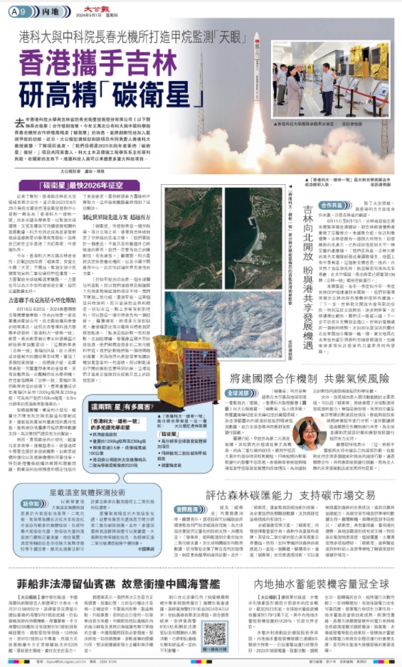
A research team led by Prof. WANG Yang (gentleman in black jacket) and HKUST Global STEM Professor SU Hui (lady in the front) conducted a visit.
Overcoming the Challenges of Satellite Miniaturization
From June 18 to 20, the 2024 Changchun International Optoelectronic Expo was held. As the first commercial remote sensing satellite company in Mainland China, Chang Guang showcased several of its flagship products, including the "HKUST-FYBB#1," which was developed in collaboration with HKUST. Mr. Xiaolei Zhang introduced the satellite in detail: "This satellite was the first of the 'Jilin-1 Kuanfu 02A' series. From planning to launch, it took about two years and achieved multiple technical breakthroughs." With performance metrics equivalent to those of the "Jilin-1 Kuanfu 01" series, the weight of the entire satellite was successfully reduced from 1,200kg to 230kg, providing users with high-resolution satellite image products with a 150km width and 0.5m resolution.
Mr.Zhang explained that miniaturizing and lightening satellites reduced manufacturing and launch costs while improving coverage and performance. This enabled faster responses and real-time data support, offering critical assistance to decision-makers.
However, achieving the miniaturization and lightweight design of satellites was not easy. Mr. Zhang noted that many technical difficulties had to be overcome during the development process, such as optimizing the satellite structure and ensuring the reliability of the deployment mechanism. Ultimately, through the unremitting efforts of the two teams, these technical challenges were successfully resolved.
Developing World-Class Solutions to Surpass the West
The "carbon satellite" marked a significant milestone. From the beginning, the teams in Hong Kong and Chang Guang aimed to create a world-class and innovative system. "If we wanted to design a product, we couldn't just copy what had been done abroad. We had to have our own originality and advancement," said Professor Su. As a result, HKUST decided to collaborate with CIOMP and CSU.CAS to formulate a globally advanced solution.
"Reducing methane emissions was a global focus. What made our project different from other international carbon monitoring missions was that we measured both carbon dioxide and methane simultaneously, and with very high accuracy. So it was an innovative technology at that point—it was a world-leading technology," Professor Su added. After thorough research and discussion, the team confirmed that the payload’s objective was to measure carbon emission sources. "Point sources referred to a number of emission points, such as coal mines, power plants, and other large emission sources, which emitted a lot of carbon dioxide and methane. We measured them very carefully, because they were also some of the most important sources of greenhouse gas growth. So the resolution of the point source space needed to be particularly high, so that we could truly carry out emission monitoring at the facility scale."
How Powerful Are These Two Satellites?
HKUST-FYBB#1
1)Highest level in civil satellite technology
2)Weight reduced from 1200kg to 230kg
3)Resolution of 0.5 meters, image swath over 150 kilometers
4)20x resolution of ESA’s Sentinel-2 optical satellite
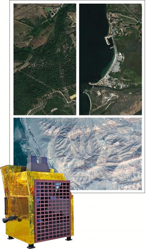
Top image:First batch of high-resolution imagery returned by HKUST–FYBB#1 satellite. Below: a 1:1 replica of the satellite.
Carbon Satellite
1)High-resolution global greenhouse gas detection project
2)Simultaneous detection of carbon dioxide (CO₂) and methane (CH₄) emissions
3)High measurement precision
Source: Ta Kung Pao
Original link: https://bit.ly/3HVynH1