Company News | Stellerus Tech Research Paper Published in Remote Sensing: Satellite Remote Sensing Data Assimilation Empowers Accurate Severe Convection Forecasting
Recently, Professor Xiefei Zhi, Chief Scientist of Stellerus Tech, together with Guo Deng's research team from the China Meteorological Administration, made significant research progress in the field of severe convective weather ensemble forecasting. Relying on observation data from the FY-2G geostationary meteorological satellite and networked radar, the research team constructed a stepwise cloud analysis assimilation initialization scheme, effectively integrating satellite remote sensing and radar observation information into the convection-allowing ensemble forecast system. This significantly improved model spin-up and short-term heavy rainfall forecasting performance. The relevant research results were recently published in the international academic journal Remote Sensing.
Refined Forecasting of Severe Convection Faces "Model Spin-Up" Challenge
Severe convective weather has small spatial and temporal scales and rapidly evolves in formation and dissipation, posing a primary technical difficulty for short-term refined forecasting. Currently, convection-allowing ensemble forecast models generally face the "model spin-up" problem. Due to the lack of effective observational constraints on cloud systems and hydrometeors in the initial field, the model often requires several hours of integration to gradually form a cloud-precipitation structure close to actual weather, thereby affecting the accuracy and timeliness of 0–6 hour severe convection forecasts.
Integrating Satellite and Radar Observations to Optimize the Initial Field of Forecasting
The FY-2G geostationary meteorological satellite can provide various cloud parameter products, such as cloud top brightness temperature and total cloud water content, with observation frequency increasing to every 30 minutes during the flood season, providing critical observational support for constructing a three-dimensional cloud microphysical initial field. Traditional ensemble forecast initial perturbations mainly focus on dynamic and thermodynamic variables such as temperature, air pressure, humidity, and wind fields, paying relatively insufficient attention to uncertainties in hydrometeor fields like cloud water, rainwater, and ice crystals.
Based on the 3 km resolution CMA-Meso convection-allowing ensemble forecast model, this study applied stepwise Newtonian relaxation (nudging) technology to gradually introduce radar and satellite-retrieved hydrometeor increments to each ensemble member. This avoided the dynamic imbalance caused by direct assimilation and achieved a reasonable construction of the hydrometeor initial field.
Forecast Skill Improved by 7.9%, Undetected Extreme Precipitation Rates Reduced
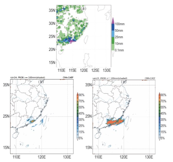
The research team conducted batch numerical experiments targeting an extreme rainstorm event in South China in August 2025. Results showed that this assimilation scheme effectively shortened the model spin-up time and produced a continuous positive impact.
The overall forecast skill in the study area improved by 2.6%–7.9% for 12–48 h forecasts, with the optimization effect being most significant around 12 h. Ensemble spread increased by 2%–5.8%, effectively mitigating the defect of insufficient ensemble spread. The identification capabilities for light rain, moderate rain, and heavy rain were all significantly enhanced, while missing reports and underestimations of extreme precipitation were markedly improved. Meanwhile, forecast errors in circulation elements at high and low altitudes were effectively suppressed.
(a) Real-time observation, and 24 h cumulative precipitation probability forecast for rainfall > 100 mm starting from 00:00 UTC on August 4; where (b) cloud analysis initialization was not applied, and (c) cloud analysis initialization was applied.
Physical mechanism analysis demonstrated that joint satellite-radar assimilation can directly reconstruct the three-dimensional hydrometeor structure and adjust mid-level thermodynamics and circulation based on latent heat of condensation, achieving synergistic optimization of multiple physical processes. Featuring high computational efficiency and strong practical applicability, this scheme can be directly implemented in operational applications, effectively supporting the technical upgrade of convection-allowing ensemble forecast systems and significantly boosting refined early warning capabilities for severe convective weather.
Stellerus Accelerates the Commercialization of Satellite Remote Sensing Research Outcomes
This research further validates the application value of satellite remote sensing observations in numerical forecasts of high-impact weather. Compared to solely using satellite data for weather monitoring, further integrating high-spatial-and-temporal-resolution satellite remote sensing data into numerical weather prediction and artificial intelligence forecasting systems is expected to fully unlock the value of satellite data, improving both accuracy and lead time for extreme weather forecasts.
As an innovative enterprise focusing on satellite remote sensing, artificial intelligence, and climate technology, Stellerus continues to advance the deep integration of space-air-ground multi-source observation data with numerical models, physical mechanisms, and artificial intelligence technologies. Relevant research results have been continuously published in international academic journals, further demonstrating the company's research and innovation capabilities in satellite remote sensing and AI meteorology. In the future, Stellerus will accelerate the commercialization of scientific research outcomes, expanding the application of related technologies in extreme weather forecasting, urban disaster warning, renewable energy meteorological services, and climate risk management. Through technological innovation, the company aims to enhance high-impact weather monitoring and forecasting capabilities, contributing to urban safety and climate resilience construction.
Reference:
Deng G, Zhi X, Zhu L, et al. Improving Convection-Allowing Ensemble Forecasts via Multi-Source Remote Sensing Data Assimilation Through Stepwise Cloud Analysis Initialization: A Remote Sensing Case Study. Remote Sensing. 2026, 18 (15), 2539; https://doi.org/10.3390/rs18152539